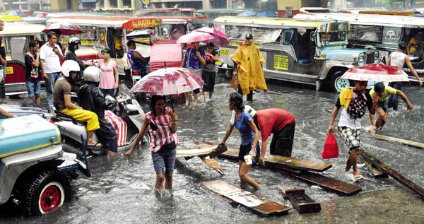
INTREPID bystanders put up a makeshift “bridge” for a fee in a flooded portion of Recto Street in Manila. Heavy rains inundated parts of Metro Manila on June 13, causing heavy traffic and stranding thousands of commuters. Edwin Bellosillo
Most Filipinos know that when the calendar page is turned to June, the season of rain, floods, dengue and suspended classes has come. Foldable umbrellas return as essentials in our bags and our ears are alert for any notices of typhoons.
Another problem many Filipinos have gotten used to during the rainy season is heavy traffic. Even though most city dwellers are already used to the daily, regular heavy traffic in Metro Manila, the rainy season can make commuting a real test of patience.
However, on a rainy Monday, June 17, thousands of motorists were trapped in unusual extreme traffic along major thoroughfares in Metro Manila.
Commuters spent hours on Edsa and on C-5 only to ply a few kilometers, with some even giving up and walking in the rain.
Some reported the experience similar to being trapped in a parking lot. Many attributed the cause of the tied-up traffic to the rains and the subsequent floods brought by Tropical Storm “Emong.”
Only a month into the Philippines’ typical rainy season, the question is: How extreme was the rainfall on that Monday to have caused the traffic chaos?
Is June’s extreme traffic the new normal for the rainy season?
Network of stations
The Manila Observatory (MO), a private, nonprofit Jesuit research institution, owns several weather stations in Metro Manila. MO operates and manages the Metro Weather network of Automated Weather Stations (AWS) and is a part of the Makati City Network of AWS.
The Metro Weather network is a partnership among MO, Chevron, Globe Telecommunications, Ateneo de Manila University and the Metro Manila Development Authority (MMDA). Data gathered from the AWS were used to collect information on the rainfall on June 17.
Heavy in south metro
Data from the AWS showed that rain fell more heavily in the southern part of Metro Manila. San Juan recorded a total rainfall accumulation of 114.6 mm.
Among the network of weather stations, West Rembo, Guadalupe, Navotas, Tayuman and Payatas also recorded the highest accumulated rainfall in the metropolis. (See Table 1.) The MMDA has pegged 50 mm as an hourly accumulated rainfall threshold for floods to occur in flood-prone areas.
For reference, during Tropical Storm “Ondoy” (Ketsana) in 2009, a total of 270 millimeter fell in six hours as recorded at the Manila Observatory, with a peak rate of 61 mm per hour. Ondoy dumped a total of 370 mm in 24 hours.
Based on the results of the analysis, Metro Manila received the biggest volume of rain on June 17 from around 3 p.m. to 8 p.m. During that period, San Juan received up to 63 mm per hour.
The heaviest rain was concentrated between 5 p.m. and 7 p.m. during which San Juan received a total of 105 mm.
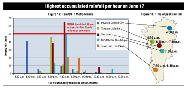
Figure 1a shows the hourly rainfall accumulation rates for the stations that received the highest volume of rainfall in Metro Manila.
Payatas received over 40 mm between 4:30 p.m. and 5:30 p.m. but little rain after this period. San Juan received the biggest amount of rainfall—concentrated in about one hour, between 6:30 p.m. and 7:30 p.m.
Guadalupe, Makati and Tayuman, Manila also received most of their rainfall during this hour while Las Piñas experienced the heaviest rain between 7:30 p.m. and 8:30 p.m. This progression of heavy rain showed that the rain pathway moved southward. (See Figure 1b.)
Impact on traffic
Data showed that there was heavy rainfall in various parts of Metro Manila especially between 6:30 p.m. and 8:30 p.m. The MMDA reported that traffic was most snarled along parts of Edsa and C-5.
The MMDA has listed a number of flood-prone areas along Edsa: Balintawak, North Avenue and Aurora Boulevard in Quezon City; Connecticut and Shaw Underpass in Mandaluyong; Ayala and Pasong Tamo Tunnels in Makati; and Taft Avenue and Harrison in Pasay City. The MMDA has also listed parts of C-5 that are vulnerable to flooding.
Cars were at a standstill at C-5 near Tiendesitas and the Edsa-Ortigas area due to impassable floods on that Monday. The MMDA reported flooding in other parts of the metropolis such as the Blumentritt and Biak na Bato areas.
The RMB Pureza area was also reported to be flooded.
Rush hour
The time of the heaviest rainfall coincided with rush hour, when most motorists and commuters were on the road to get home.
Data from the weather stations showed that there was scant recorded rainfall before 3 p.m. in the metropolis, so the ground and other pathways where the rain could flow were not necessarily saturated before the downpour.
The sudden heavy rainfall within a few hours accumulated quickly and caused floods. The runoff may have also overwhelmed drainage canals and waterways. This, along with other factors such as slope, obstructions or construction on the road, may have contributed to the flash floods and caused several choke points along the flood-prone areas of Edsa and C-5.
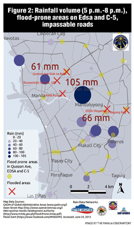
The MMDA information on flood-prone areas and the reported flooded areas on June 17 were combined to produce a map of the flooded areas vis-à-vis the points with heavy rainfall, with emphasis on Edsa, C-5 and Quezon Avenue. (See Figure 2.)
The high rainfall volume recorded at Tayuman station matched the cause of the reported flooding in Blumentritt and the Biak na Bato areas. Rainfall in areas toward Mandaluyong, Makati and Pateros may have affected Edsa between Ortigas and Guadalupe.
The heavy rain—concentrated in a few hours, particularly during the peak traveling time—was a major cause of the congested thoroughfares.
Rainfall was heavy due to the regular monsoon season and enhanced by the presence of Emong in the Philippine area of responsibility.
New challenges
An average of 19 tropical cyclones (depressions, storms and typhoons) enter the Philippine area of responsibility every year, especially during the monsoon season until December.
However, as many Filipinos now realize, it doesn’t take a typhoon to create traffic chaos anymore. “Regular” monsoon rain events, such as the habagat and June 17’s rainfall, show that Metro Manila faces new challenges each rainy season.
Climate change
Climate change may also alter precipitation patterns, creating a “new normal” of heavy and intense rainfall, thus making extreme events more frequent, according to the Intergovernmental Panel on Climate Change.
The rainy season is predicted to be much wetter than previously experienced, which poses real challenges to public roads and infrastructure.
In a megacity like Metro Manila, the risk of traffic chaos is high when combined with heavy rainfall, a high volume of cars, vulnerable roads and few alternatives to major thoroughfares.
Similar to that Monday night, the heaviest rain can pour at peak travel times and many motorists may be trapped for hours in bad traffic.
Climate change threatens to make these situations worse because of the potential for more extremely heavy rains.
It is crucial for the Philippines to engage in timely and efficient monitoring of the weather and road conditions, and in disseminating accurate information to the public.
(Monica Ortiz and Genie Lorenzo are research associates at the Manila Observatory [MO]. Gemma Narisma, Ph.D. is the associate director for research at MO and James Simpas, Ph.D. is the head of the air quality dynamics and instrumentation and technology development programs.)


